Hydrotowns 1: Background
Intro
Hydrotowns is the working title for this project, which aims to look into water and environmental management through the lens of human settlement and system design. Overall, I would like to use this as an opportunity to create divergent but grounded ideas of what the future could look like under various adaptive strategies. As this is a self-directed project, it really only has a meta-aim to build up GIS skills, particularly in terms of visualisation and the creation of programmed models - at the end of the day I see this as an explorative and inquisitive process but nevertheless I will try to lay down some of the background and aims as I see it at this stage:
Background
In the last few years, water has been the rallying concept for a lot of the things I have been thinking about. It seems clear to me that better stewardship and management of water will be a necessary part of responding to the challenges brought by climate change and how these interact with human and natural systems. There is a lot to unpack in that statement and I would eventually like to flesh it out a bit, but for now I would like to focus on the climate side of things.
The IPCC has a report out which discusses the impacts of a 1.5°C rise in mean temperatures. It seems (to me) most likely that we will reach at least this level of warming. Currently we are sitting around 1°C and the same report shows that even an incredibly drastic reduction in CO2 emissions (zero net emissions by 2055) will have a fair chance of exceeding the 1.5°C threshold.
The report also outlines the climate modelling predictions for what such a rise in temperature will mean on a local level. It appears that (amongst other things) the subtropical regions of the world are in for significant changes to the amount of precipitation:
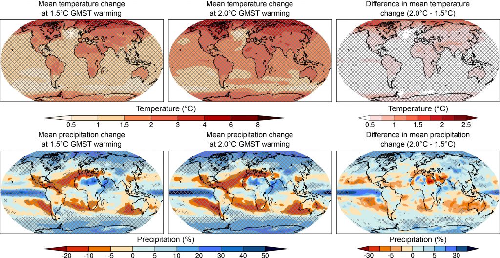
Apparently, it is also likely that climate is going to become more erratic but there is less certainty around how this will play out. In any event, the experiences of the water crises affecting Cape Town and the Western Cape a few years ago show that these issues are more than just musings. They represent a very real challenge (threat?) which must be addressed holistically - i.e. not only focusing on consumer/end-of-pipe interventions but also on issues such as agriculture and environmental requirements.
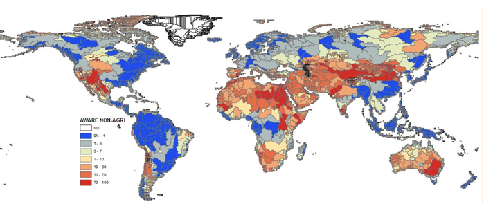
Personally, my feeling is that it would be worth exploring adaptations and interventions in terms of how we use and manage water even under the current conditions. The figure below shows an indicator index for water scarcity, as an average annual value. It is commonly stated that South Africa is a water-stressed country but this is one way of quantifying it. Note that this particular quantification can in fact underestimate the practical implications of water scarcity as in many cases this scarcity is unevenly distributed across an average year (and not to say anything of longer term variation).
As I mentioned, this is however not just a story of climate and looking to a future where the climate will be different. It also involves consideration of the relationship this has with the human and natural systems that we are part of. Water obviously underpins both human activities as well as the vast majority of natural or ecological functions.
Significant changes in the temporal and spatial distribution of water will further disrupt what is generally an already imbalanced system. Although somewhat trite, personally I think that the most interesting outcomes will come from solutions which (at the very least) leave space for nature and natural processes whilst (in the best case) working synergistically to improve or mitigate outcomes across the board. There is a continuum between "concrete canal to move runoff to the sea as fast as possible" and "reconstructed wetlands and riparian corridors to slow water and allow for infiltration" - with one end of the spectrum more or less being the status quo, I would like to explore what could be done in moving further along that line.
In the process, I want to do some interesting calculations and produce some interesting maps and datasets. I doubt it will be earth shattering but it gives me somewhere to direct a lot of the nervous energy I feel around these issues both in terms of quantifying the status quo and imagining potential solutions or adaptations. As I see it now, I want to try and address the following objectives:
Objectives
There are a lot of concepts down here that I would probably want to give more background on but:
- Develop an area-based model, likely based on watersheds, which demarcates (nested?) water management areas.
There are various extant water management areas, whether irrigation schemes or government-mediated but I think that these tend to have a narrower interest than what I am thinking of. On the other hand there is a well-developed catchment hierarchy down to quinary level that is used for some scientific work. In any case I want to look into these a little bit and at the very least understand how they link together a bit better.
- Calculate flow data based on a DEM, precipitation data and perhaps other parameters like lithology
The basic approach uses commonly applied flow accumulation algorithms to calculate flow paths but I think it could be interesting to try and link this to the actual volume of flow in some way using additional data. Correlation and normalisation could be powerful tools to move from qualitative relationships to more quantitative when you don't necessarily have a model which incorporates all the aspects mechanically.
It would be very interesting to try and collate a number of different sources for river and stream data in some way. This also ties into the flow accumulation calculcation because this could be associated with existing data for streams to a) look into thresholds for perennial/non-perennial (i.e. from topographic map data) and b) link flow paths to river names where possible.
- Determine riparian and terrestrial corridors which enable greater connectivity and functioning of ecological processes
This has to do with a few related issues. On the one hand, rivers, wetlands and estuaries are often heavily impacted by human activities and will in many cases need both protection and rehabilitation to restore functionality. They are also important as corridors which create connectivity between mountain and sea. Terrestrial corridors I am less certain about but I think it is possible to imagine a related network which integrates with a riparian network to connect and strengthen remnant natural vegetation as well as protected areas. Alternatively we can create also think about watersheds as a kind of inverse river network and think about how such corridors may be useful.
Either way I think there are some interesting ideas to explore along these lines. One example I can think of relates to the management of invasive species, which often are strongly associated with riparian zones. A corridor can then also act as a management area for this purpose.
- Determine how human settlement and agriculture layers and reticulation can or should be overlain on this backdrop
All the above, however, need human resources to manage them if we want to play a supporting/stewardship role. As such I also want to imagine what different interpretations of stewardship could look like and how human systems can be set up. This objective is a bit further down the chain (see below) so it is not as fleshed out and what I want to do around this could change somewhat. One of the things I was thinking about was using tools from procedural generation for some parts of the "model".
Roadmap
- Hydrology
- Rainfall
- Groundwater
- Streams
- Watersheds
- Environmental
- Corridors
- Riparian
- Terrestrial
- Ecological reserve and restoration
- Corridors
- Urban
- Management areas
- Connectivity
- Layout & Reticulation
- Agricultural
- Layout & Reticulation
- Reticulation
Exeunt
Anyway, that is what I think can get out at this stage. The next post will probably be looking into the hydrology. I want to give more detail and explain some concepts a bit better.
DW